
Across Africa, millions of smallholder farmers face a quiet financial crisis. Only about 2% of African farmers carry agricultural insurance, compared to 20% in other developing regions around the world. At the same time, the continent faces an agricultural financing gap exceeding $100 billion, with formal bank lending allocating just 5% of its total loans to the sector.
This financial gap creates a major paradox. Agriculture is the single largest employer in Africa, yet the people who work the land operate with almost no safety net. When drought, pests, or unexpected weather hit, farmers lose their livelihoods, and lenders face massive loan defaults.
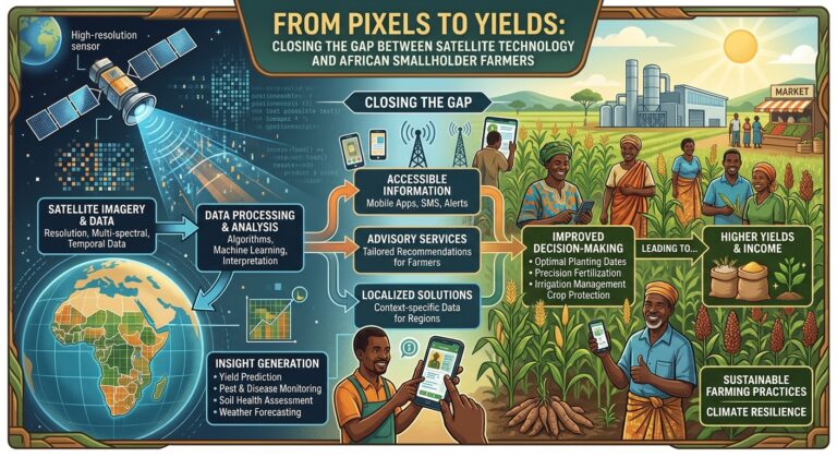
On paper, space technology offers an ideal solution. Earth observation satellites continuously orbit the planet, generating rich data on rainfall patterns, soil moisture, and crop health. European and American space agencies provide vast amounts of this data for free. However, a major challenge remains: how do we translate raw satellite images into practical, low-cost financial products and advice for smallholder farmers on the ground?
Resolving this “last-mile” challenge requires shifting our focus away from the technology itself and toward the business models, delivery channels, and financial structures that bring satellite data to life.
The Core Gap: Data Is Not the Same as Advice
A smallholder farmer does not make decisions based on high-level regional weather trends. They make hyper-local, time-sensitive choices:
- Should I plant my seeds this week or wait for more rain?
- Is this crop damage caused by disease or lack of fertilizer?
- Can I afford insurance for this coming season?
As Aliou Maïga, Regional Industry Director for the Financial Institutions Group in Africa at the International Finance Corporation (IFC), highlighted on the TechAfrica News Podcast:
“If you want to create jobs in Africa, the biggest employer in Africa is agriculture.”
Despite agriculture’s central role in the economy, standard satellite maps rarely help individual farmers. A map showing average rainfall across an entire district provides little value when a crop fails on a single, one-hectare plot.
The primary barrier to adoption is not a lack of interest from farmers. Studies across Kenya, Tanzania, and Uganda show that over 70% of farmers are willing to adopt digital tools if they receive proper training and affordable access. However, field research in Nakuru County, Kenya, revealed a stark gap between interest and reality: out of 53 farmers surveyed, only two used internet-based agricultural tools.
Most smallholders lack smartphones, reliable internet, or computer literacy. The digital tools that succeed bridge this gap by using basic, accessible channels.
For example, platforms like AskMolemi convert open satellite data into simple text alerts sent over WhatsApp or standard SMS. Instead of expecting a farmer to log into a complex dashboard, the platform sends direct, plain-language messages about rainfall anomalies and crop health straight to basic feature phones.
Why Integrated Distribution Networks Are the True Infrastructure
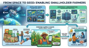
Smallholder farmers rarely buy standalone raw data. What they actually buy are tangible items: seeds, fertilizer, micro-loans, and crop insurance. Because of this, the most effective way to deliver satellite intelligence is through existing market intermediaries—such as input dealers, credit officers, extension agents, and agricultural cooperatives.
Early attempts to sell low-cost insurance directly to farmers failed because the cost of finding, selling to, and collecting payments from millions of isolated individuals was far too high. The technology only scaled up when insurance was embedded directly into the supply chains farmers already used.
Successful Integration Models
- ACRE Africa (Bima Pima): Rather than selling insurance separately, ACRE Africa packages cover as a scratch card inside bags of seed or fertilizer. Farmers activate the policy by sending a simple mobile code containing their location. Automated satellite weather data continuously monitors the plot. If a severe drought occurs, the system automatically sends a payout directly to the farmer’s mobile wallet—eliminating the need for a physical inspector to visit the farm.
- Pula: Agricultural technology firm Pula embeds Area Yield Index Insurance directly into government input programs and farm loans. By combining satellite insights with historical yield baselines, Pula triggers automated payouts across entire zones when yields fall below targets. This approach has allowed Pula to reach over 24 million farmers, protect more than $2.8 billion in farm investments, and deliver $136.5 million in payouts.
- SatSure and KALRO: In Kenya, satellite analytics firm SatSure partnered with the Kenya Agricultural and Livestock Research Organisation (KALRO). Instead of reaching out to farmers individually, SatSure feeds satellite data directly into KALRO’s network of state extension officers. The extension workers then deliver data-driven technical advice to farmers during routine field visits.
Follow the Money: Why Lenders and Underwriters Are the Real Buyers
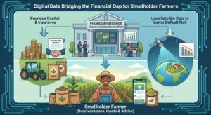
When satellite technology scales across African agriculture, the paying customer is rarely the individual farmer. Instead, the real buyers are banks, microfinance institutions, and insurance underwriters.
Financial institutions that lend to farmers carry significant default risk. By using satellite analytics, these institutions reduce uncertainty, lower their underwriting costs, and protect their loan portfolios.
This model creates a winning scenario for both sides:
- For Lenders: ACRE Africa facilitated insured loans for nearly 500,000 smallholders in 2025, unlocking approximately $150 million in private agricultural credit.
- For Agritech Providers: Ghana-based Degas Limited uses AI and satellite monitoring to manage precision farming and credit scoring across 122,000 acres. By using satellite data to assess risk, Degas has funded over 86,000 farmers, doubled their average farm incomes, and achieved a 95% loan repayment rate.
For commercial lenders, that 95% repayment rate is the key metric. The farmer never pays for the satellite images directly; they simply repay a loan that the imagery helped secure and protect.
Technical and Financial Realities at the Plot Level
Providing satellite analytics for small farms faces two major challenges: resolution constraints and high data costs.
1. Spatial Resolution Limitations
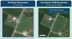
The European Space Agency’s Sentinel-2 satellites offer free imagery at a 10-meter resolution. While 10 meters is detailed enough for large agricultural fields in North America or Europe, African smallholder farms are often small, irregularly shaped, and under one hectare in size.
At a 10-meter resolution, a single pixel often covers parts of multiple fields, trees, and roads simultaneously—a problem known as the “mixed-pixel effect.” This makes it difficult to measure crop health on an individual farm.
A 2025 survey by Tropentag of 177 Earth observation experts across Eastern and Southern Africa named access to Very High-Resolution (VHR) imagery as a top policy priority. Free 10-meter data is simply too coarse for tiny, fragmented plots.
2. High Software and Data Costs
Commercial crop-monitoring platforms, such as EOS Data Analytics, typically charge starting fees around $1.90 per hectare annually.
While a large commercial estate can easily absorb this cost, a subsistence farmer working a single hectare cannot justify spending extra cash on digital monitoring when every dollar is needed for basic inputs like seed and fertilizer.
While enterprise platforms like OneSoil Pro have mapped over 100,000 hectares across Africa, their rapid growth is driven by commercial agribusinesses and agronomy consultancies—not resource-constrained smallholders.
Because smallholders cannot afford standalone data subscriptions, the cost of high-resolution data must be absorbed by the banks, seed producers, or buyers who rely on those crops.
Public Policy vs. Ground-Level Reality
Public space initiatives across Africa have made great progress in building technical capacity. Programs like GMES & Africa (Global Monitoring for Environment and Security) have trained over 12,000 specialists and established environmental monitoring networks across 51 countries.
At the regional level, the African Space Agency (AfSA) coordinates space policies across African Union member states. Operating with a 5-year budget allocation of $35.4 million, AfSA focuses primarily on policy alignment, international cooperation, and supporting national space programs rather than running commercial operations.
While public space investments are vital for training local talent and setting national policies, public programs rarely deliver direct services to individual farmers. Instead, commercial agritech companies bridge this gap. They take free, open-access data from global agencies like NASA and the European Space Agency, combine it with proprietary machine learning models, and deliver practical tools directly to local financial markets.
The Path Forward: Investing in Intermediaries
Africa’s agricultural data challenge is not caused by a shortage of satellites. More than 18 African nations own space assets, and global Earth observation data is more accessible than ever before.
The real bottleneck lies in the middle layer: the distribution networks that connect space technology to ground-level agriculture.
Satellite data creates true economic value only when it is embedded directly into everyday financial, input, and retail supply chains. The organizations that successfully translate raw pixels into bankable credit, automated micro-insurance, and risk-rated loans will close the final gap—delivering real financial security and long-term productivity to millions of smallholder farmers.